Innovative Software for Safe Airport Operations
For airport planners, tracking permanent and temporary obstacles at the airport or in its vicinity is vital for safe operations. SkySAFE™, a CAD-based software, allows users to accurately and efficiently analyze obstacles to ensure these do not penetrate or threaten the obstacle limitation surfaces (OLS) defined in regulatory guidelines. SkySAFE is an effective tool for airport planners, operators and safety managers involved in protecting and monitoring the airfield and its runway departure and approach paths.
Analyze existing or potential obstacles in an airport's surrounding environment to meet regulatory guidelines.
Platform Compatibility
We strive to keep our products compatible with the latest operating systems and platforms. Find the latest product compatibility information for Transoft products.
English
What Makes SkySAFE Unique
Reduce time-consuming tasks
Effortlessly build, edit, rebuild, and assess limitation surfaces of any imported obstacle or terrain in minutes. Resulting in a reduction in CAD drawing time and decreased plan generation costs. The software detects obstacle and terrain violations with defined limitation surfaces and obstacle-free zones, to help you avoid costly errors.
Make better, more-informed decisions
SkySAFE features a toolset to analyze obstacle interference and clearance compliance to help make informed decisions. The software allows you to clearly identify obstacles that require review, both with high-conspicuity labeling in the drawing and in complete export CSV reports.
Comply with regulatory standards
With regulations built-in, there is no need to cross reference multiple documents. Compliance with International Civil Aviation Organization (ICAO), Federal Aviation Administration (FAA), European Aviation Safety Agency (EASA) and several other national regulatory frameworks helps to ensure maximum safety in all aircraft operations.
Use with ease and accuracy
SkySAFE’s workflow processes ensure that no critical entry item is missed. The software is based on user input and software program methods that provide the utmost in accuracy with regard to items such as runway types (lengths and widths), displaced thresholds, longitudinal runway elevations, surface locations and dimensions, and overall 3D depictions.
Features
Logical Workflow for Accuracy and Ease of Use
SkySAFE’s workflow processes ensure that no critical entry item is missed. The software is based on user input and software program methods that provide the utmost in accuracy with regard to items such as runway types (lengths and widths), displaced thresholds, longitudinal runway elevations, surface locations and dimensions, and overall 3D depictions. All this means a reduction in CAD drawing time and decreased plan generation costs.
Explore Features
Fixed or Temporary Obstacles
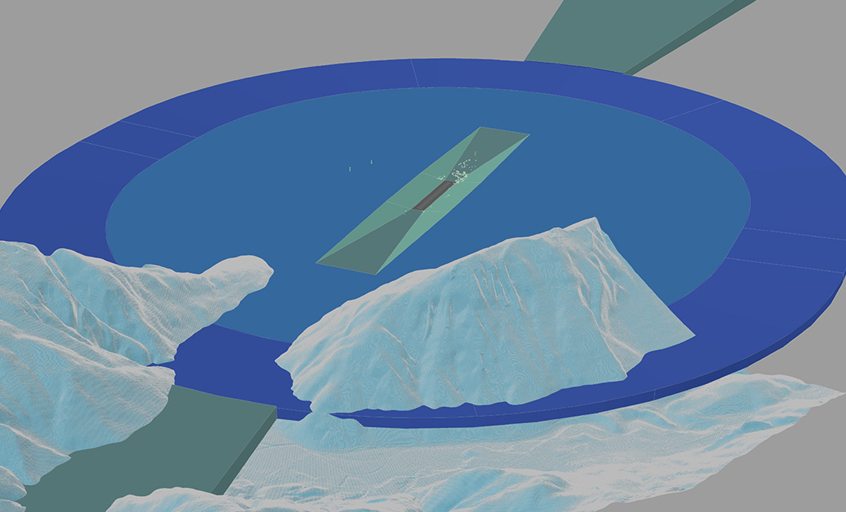
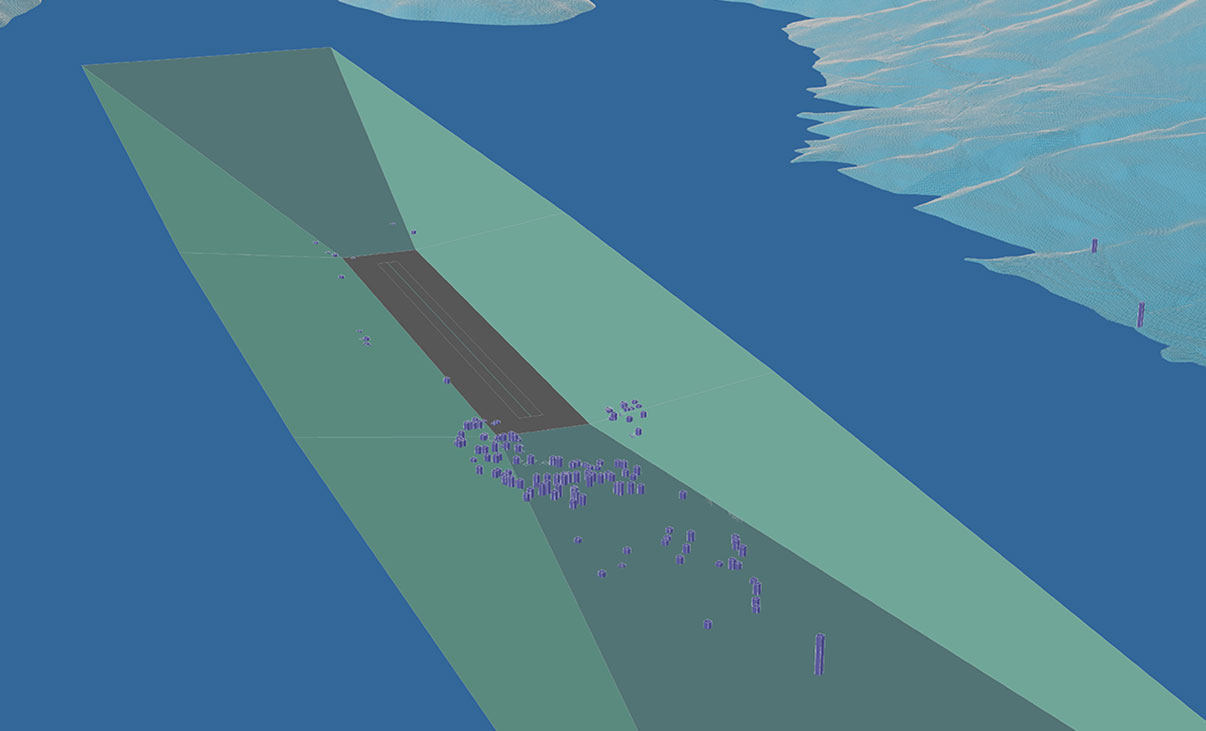
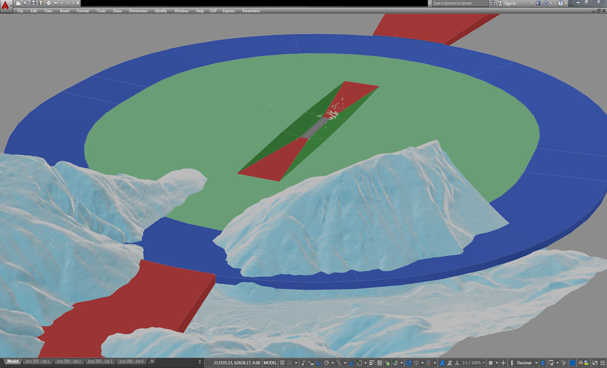
Once an airport’s operational environment has been modeled with SkySAFE, only a few clicks are required to analyze the impact of fixed objects such as buildings, power lines, lighting pylons or trees. What’s more, these same commands can also be used to quickly and efficiently analyze temporary obstacles, such as mobile cranes. Obstacles are uniquely numbered with logical filtering to review only those that penetrate the protected airspace, quantified with the delta elevation above the surface.
International and National Regulations
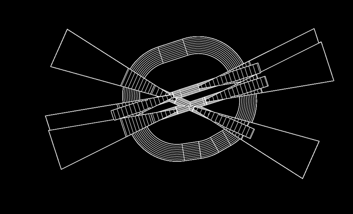
SkySAFE features a toolset to generate ICAO, EASA, FAA, Transport Canada, BMVBW (Germany) or PSA (France) limitation surfaces in a 2D or 3D environment.
Terrain Interference Analysis
SkySAFE offers functions for fast and reliable analysis based on geographical input. These capabilities can be utilized to create a SkySAFE terrain from imported survey coordinate data, or reference an Autodesk Civil 3D® surface, to assess resulting clearances and potential interference with approach and departure procedures.
Complex Multi-runway Environments
Accurately model an airport’s operational environment, with single or multiple runways, parallel or crossing. A single merged surface model can be generated for all runways, or surfaces can be created individually, all in just a matter of seconds. Further details such as contour lines or cross sections can be added to further communicate results.
What’s New in SkySAFE
New features, fixes, and other improvements built specifically with your feedback.
This latest version is launched as SkySAFE 2024 as Transoft Solutions is adopting a new annual product versioning system. This new approach makes it easier to understand which version you are running to help ensure that you stay up to date with the latest features, improvements, and security patches.
Key features in this new release are:
- The Create Obstacle import function now supports formatted data
- The new Obstacle Charts function
- Now supports Bricsys BricsCAD V24
- Now, with Create Obstacle, multiple CAD objects can be selected from the drawing to create SkySAFE obstacles in a single action
- The Evaluate Obstacle Intersection report now lists all overlapping surface penetrations by one or more obstacles
• Compatibility with AutoCAD® 2024, BricsCAD® V23
• Regulations: ICAO Annex 14 Volume 1 9th Edition regulations have been added
• Perform PAPI Analysis: Extended to support EASA CS-ADR-DSN Issue 5 and 6, FAA AC 150/5340-30J, Canada TP312 4th and 5th Editions, and Germany BMBVS regulations
- Compatibility with Autodesk AutoCAD® and Civil 3D® 2023
- Support for FAA AC 150/5300-13B regulations
- Support for EASA CS-ADR-DSN Issue 6 regulations
- All-new command to create ICAO, EASA and PSA (France) PAPI / APAPI surfaces
- Improvements to terrain intersection reporting
- New AutoCAD ribbon, toolbar and menu
- New EASA CS-ADR-DSN Issue 3 regulations
- New (red) marking of obstacles that intersect an Obstacle Limitation Surface
- Proposed displaced threshold elevations using centerline point data interpolation
Licensing Options
Transoft offers a range of licensing options to help small, sole proprietorships right on up to the largest multinational organizations meet their transportation design and analysis needs.
User Subscription License (USL) is a model where a set number of Subscribed Users are assigned dedicated access to the software through their unique logins for the duration of the license term. The software can be installed and used by a Subscribed User on multiple workstations.
Each Subscribed User represents one individual and their login and password, which cannot be shared with other users. Software activation is an easy process and can be done over the Internet.
Why Choose the USL Option
User Subscription License offers a cost-effective way for small businesses to start with one user and grow by adding additional users. For larger organizations, it will offer more flexibility in user administration and management via the My Transoft Portal. Furthermore, it can easily handle scalability and budgeting as per the business needs defined by the number of users.
Key Benefits of USL License
- Automatic updates, new features, and content
Bug fixes, compatibility, and new version releases. - Easily manage your changing business needs
With enhanced scalability and user management. - Install the software and log in from anywhere
Access your workstation, laptop, or personal desktop. - Unlimited technical support
Receive premium assistance for all your deployments and technical support needs. - Invitations to learning-focused webinars
Attend learning-focused webinars from our product experts and learn how our software can help streamline design processes. - Flexible user license options
Choose from single to multiple user packages to meet your business needs. - Simple user administration
User Management can be performed in the My Transoft Portal, via invitation links or by Identity Provider Single Sign-on with User Provisioning.
Have more questions about USL? See the FAQ here.
Team Subscription License (TSL) is a license option that is intended to support casual or occasional users of the software. The size of a TSL is represented as a number of allocatable seats.
Why Choose the TSL Option
While User Subscription Licenses are better for dedicated users, Team Subscription Licenses can be a good complement to these if your organization has occasional, less heavy users of the software.
How it Works
Each user of a TSL must have an account in the My Transoft Portal to request a license. Internet access is required for this process.
When an end user starts the software product on their workstation, the software will connect to the My Transoft Portal and will determine if any of the seats are available. If a seat is available, it will be allocated and dedicated to that end user who will have unrestricted access to it for 24 hours. At the end of the 24-hour period the seat allocation will automatically expire, and another user will be able to claim it.
Once all the TSL seats are allocated at a given time, no other end user will be able to use that license until the 24-hour period expires and one of the seats is automatically deallocated.
Key Benefits of TSL
- More flexibility for your team members
Allows access to software for casual users without having to spend on dedicated licenses for all users. - Less administrative effort by IT
Easy access to software for casual users without IT having to allocate or transfer licenses amongst team members, self-administered by users with automatic 24-hour lock. - Combined Team & User Subscription option
Flexibility of mixing plans according to the needs of different user types. - Automatic updates, new features, and content
Bug fixes, compatibility, new version releases, or vehicle guidelines are automatically available to you. - Easily manage your changing business needs
With enhanced scalability and user management. - Install the software and log in from anywhere
Access your workstation, laptop, or personal desktop with Single Sign-on. - Unlimited technical support
Receive premium assistance for all your deployments and technical support needs. - Invitations to learning-focused webinars
Attend learning-focused webinars from our product experts and learn how our software can help streamline design processes. - Simple user administration
User Management can be performed in the My Transoft Portal, via invitation links or by Identity Provider Single Sign-on with User Provisioning.
Transoft Support
We take pride in delivering complete customer satisfaction. Get help with products, downloads, technical support, and more.
My Transoft Portal
Transoft's product enhancements are periodically released to provide access to new features, fixes, and security updates. For many products, you can find these updates and download them directly from My Transoft Portal.
Software License Agreement
For information on terms and conditions detailing the usage of our software, please refer to Transoft’s Software License Agreement (SLA).
Software FAQ
Search our extensive product knowledgebase that address some of the most frequently asked questions regarding Transoft ‘s software.
Help Desk
Find answers to your issues on a variety of topics or request Technical Support. Get help with downloading and installing your software, managing your account, product compatibility and much more.
Licensing Options
Transoft offers a range of licensing options to help small, sole proprietorships right on up to the largest multinational organizations meet their transportation design and analysis needs.
Project Support Services
Need assistance with custom drawings and content creation related to your project design work? Transoft’s team of consultants can help. We deliver fast and helpful services for clients requesting additional assistance with drawings and simulations related to their project design work.
Training
We offer many excellent opportunities for you to take a more interactive approach in learning about our solutions. From webinars to how to videos, find what you need here.
SkySAFE Videos
Request a Quote
Thank you for your interest in SkySAFE. Fill out the form to receive information on purchasing and licensing options or if you have questions in general about the software.
On business days, you can expect a response within 24 hours of your request.